Henley Whalers - Annual Long Row

Version 24/7/17

Possibilities for 2017 & the Future

Home

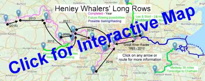
Henley Whalers accomplish an Annual Autumn two-day Long Row.
They have navigated the River Thames in stages from Lechlade to Woolwich, and the River Wey.

Lechlade to Abingdon - 2013 . 2 days. 40 miles. 14 locks
Abingdon to Henley - 2012 . 2 days. 40 miles. 12 locks
Henley to Walton - 2014 . 2 days. 36 miles. 14 locks
Walton to Putney (Olympic Torch 2012)
Chiswick to Greenwich Queen's Diamond Jubilee Pageant 2012 .
Richmond to Woolwich Reach - Great River Races 1993 - 2012 eg 2007
Gallions Reach to Chiswick - 2015 . 1 day. 20 miles. 2 locks.

Short sections:-
Whitchurch to Henley 2009
Henley, Sonning, Henley 2011,
Henley to Windsor 2010.
"Three men in a canoe", Crickalde to Lechlade 2015.

2016 River Wey and Thames. Godalming to Kingston. 2 days + Fri. 30 miles. 18 locks.


Possibilities for 2017 & the Future? - Click links for details.

Rowing - River Kennet (K&A Canal) - Newbury to Reading, then Henley. - Mainly rural. Very local! 29 miles + 13 Locks.

Rowing - Lee and Stort Navigation. - eg Hoddesdon to Bow Creek
Mixed rural and urban/industrial. 24 miles (TBC) + Locks.

Rowing - River Medway . - Tonbridge to Rochester/Chatham. -"The Garden of England" and Maritime Heritage. Very green and mainly tranquil, with an Historic finish. 33 miles + 10 Locks. - PW has some experience of this area.- A "Taster" for a Medway Raid?

Sailing - Thames to the sea. - eg Gallions Point to Southend, Sheerness or Rochester - 35 miles Gallions to Sheerness, or reverse (tide-dependant). - PW has experience of this area - Another "Taster" for a Medway Raid?

A Future English Raid? - The Medway, its Estuary, and The Swale - An estuary / bay area of creeks and islands, a similar size to Golfe Du Morbihan - Famous for wildlife, Rochester Castle & Cathedral, Chatham Historic Dockyard, Isle of Sheppey, Harty Ferry, Faversham Creek, Real Ales!

Whalers - Initial survey closed midnight Sunday 23rd July.

Long Rows.  Interactive map
Click for interactive map.
A crew member on the "Wey" trip said;
...Other canal or navigation waterways would seem worth investigating. The only drawback is the narrow and sometimes reed-choked sections that can make rowing difficult; having a couple of canoe paddles aboard would alleviate that.
Thanks again! . SM

Rowing - River Kennet (K&A Canal), Newbury to Reading, then Henley.
Mainly rural. Very local! 29 miles.
(20 miles Newbury to Reading + 20 Locks . 9 miles Reading to Henley + 4 Locks).

DESCRIPTIONS
Canal Guide.co.uk - Kennet & Avon . History. Route description with pictures. .
Jim Shead Waterways . Kennet & Avon .Distances. Details, Links to Pictures (loads). Many other links.
Canal Plan.org.uk .River Kennet. Useful map and chart.
Waterway Routes - Might be useful?

Canal & River Trust - Kennet & Avon . Useful for Map, stoppages, etc.- C&RT license required.

Slipway -
Newbury Marina. Mill Lane, RG14 5SG. 01 635 282 208, 07584 566 197. email.
Boatlaunch . (Use the map to find slipway then details)
I W A . K & A - List of boatyards.

Canal Junction.com .K & A (doesn't add much.).

K&A Map
Map - Newbury to Henley

The Cunning Man Burfield
Slipway - Newbury

The Cunning Man Burfield
Kennet at Cunning Man pub

Back to The "Future"


Rowing
- Lee and Stort Navigation. eg Hoddesdon to Bow Creek
Mixed rural and urban/industrial. 24 miles (TBC) + Locks.

DESCRIPTIONS
Canal Guide.co.uk .Lee & Stort - History. Route description with pictures.
Jim Shead Waterways . Lee & Stort .Distances. Details, Links to Pictures (loads). Many other links.
Canal Plan.org.uk ..Lee & Stort. Useful map and chart.
Waterway Routes.co.uk .- Lee & Stort, Limehouse Basin, River Lee, River Stort, Hertford Union - Tables of distances, etc. Cruising maps to buy.

NAVIGATION, etc
Canal & River Trust .River Lee Navigation - Useful for Map, stoppages, etc.- C&RT license required.
Boaters'Guide to London's Waterways - Info and maps.

Slipways - Top end
Lee Valley Marina. (& crane). Stanstead Abbas, Herts SG12 8AL, 01920 870 499, .email .
Rye House, Rye Rd, Hoddesdon, EN11 0EH. 01992 465151 ? . Lee Valley Park (Free? but need permission).
Hallingbury Marina ?. 01279 723568.. email.
Boatlaunch . (Use the map to find slipway then details)
I W A. - L&S - List of boatyards.

Bottom end - At Thames, need to consider - Tide height & direction. Possible slipways.

Bob has kindly offered to do the on-site research for this region, and currently suggests:-
"Possible itineraries might include:

1. Friday PM: Launch at Lee Valley Marina (Stanstead Abbots) public slipway see Boatlaunch
   Up to Hertford to moor overnight.
   Hertford -> Thames (at Bow, or Limehouse via the Cut). Through the Olympic Park towards the end.
   Total trip (excl. Fri) under 30 miles 19? locks
.
OR
2. Fri PM: Launch at Kecksy’s Farm (Sawbridgeworth) 51.820573, 0.158198 (but slipway will need checking)
   Up to Little Hallingbury marina or Stortford to moor overnight.
   Stortford -> Thames as above
   Total trip (excl. Fri) 32 miles 30? locks
   Alternative might be to crane in at Little Hallingbury if they can do it.

Both the above are shorter than our normal two day rows, but we’d need to add time to reach whatever slipway we finish at and possibly account for the tide. If Poplar Rowing Club, we could potentially choose to emerge at whichever of Limehouse or Bow gives us the best passage to the slipway for the state of the tide."

L&S Map
Map - Lee & Stort

River Lee Boat
Lee Valley Slipway

River Lee Boat
Lee & Stort Navigation

Back to The "Future"


Rowing
- River Medway - "CASTLE to CASTLE" (And three forts between) - Tonbridge to Upnor (Rochester). - (Could be a useful "TASTER" for a Medway Raid).
"The Garden of England" and Maritime Heritage. Very green and mainly tranquil, with an Historic finish. 33 miles.
(Non-tidal 18 miles + 10 Locks . Tidal 15 miles aprox.)
(PW has experience of parts of this river.)

DESCRIPTIONS
Jim Shead Waterways .Medway - Distances. Details, Misc links.
Canal Plan.org.uk - Medway - Non-tidal section - Useful map and chart.
Canal Plan.org.uk - Medway - Tidal section - Useful map and chart.

NAVIGATION, etc
Environment Agency - Medway - Bridges, locks, facilities for boaters. - EA license required.
Environment Agency - Medway booklet. pdf. Maps, guides, practical info.
EA. Map pdf - Pretty map with loads of useful details, Tonbridge to Allington (tidal lock) Useful !
I W A . Includes contact details for tidal section

Slipways - Top end -
Tonbridge Castle - Free? - Parking £4.50/day - TN11 9AS - Picture -
Boatlaunch . (Use the map to find slipway then details)
Slipways - Bottom end:-
Cuxton Marina, Hoist/Crane.
Elmhaven Marina. Slipway
Medway Bridge Marina Hoist/Crane.
Rochester Cruising Club - Possible drop-in for town / tide
MDL Marina, Crane.
Upnor Sailing Club.
Medway Yacht Club - Looks favourite!
Hundred of Hoo Sailing Club. (Mud?)
Hooness Yacht Club. (Mud?)
Gillingham pier, Slipway 51.397289, 0.554601 Picture. Fall-back.
Seegas Sailing Club. only gravel/sand slip.
Mariners Farm Slipway. Too far?
Queenborough Yacht Club. Too far.
Isle of Sheppey Sailing Club. Too far.
Queenborough slip Picture. Too far.
Swale Marina (Conyer), Slipway & Cradle. Too far.
[Probably not:- Strand Slip . The Strand . Gillingham Marina . Harty Ferry Inn . Oare - See Boatlaunch].

LOGISTICS Example - (updated 15/7/17) :-
Car - Henley to Tonbridge - 73 miles. 1hr30mins.
Day 0 - Launch Molly at Tonbridge and moor for night. Trailer to Maidstone or "Chatham". Home or local accomm.
Day 1 - Row Tonbridge to Maidstone 18 miles + 9 Locks. (27 "lock-miles"). Moor in Maidstone/Allington.
Overnight + Accommodation -
Maidstone = Plenty of dinner venues. B&Bs: Catnap . Rock House . Rocky Hill House . Travelodge (on river) . Premier Inn.
or Allington Lock Malta Inn 01622 717 251 =(?)Premier Inn Sandling , "Village Hotels" here or here (= Victory pub?), (otherwise "Premier Maidstone-Allington" not so handy, Maidstone central would be better).
Day 2 - Maidstone to Allington - Non-tidal 2 miles. Allington Lock. To "Chatham" - Tidal 12 miles. Must be ebb tide. Maybe visit Rochester Castle/Cathedral, Historic Dockyards, Fort Amhurst. Slip Molly out at "Chatham".
Slipway = Probably Medway Yacht Club.
Car - Chatham to Henley 91 miles - 2hrs 20.

(Canal Guide.co.uk = Nope) - ("Waterways Routes" = nope)

Medway Map
Map - River Medway

Aylesford Bridge
Aylesford

Rochester Castle
Rochester

Other pics
Aylesford Barges

Chatham

Back to The "Future"


Sailing
- Thames to the sea - eg Gallions Point to Southend, Sheerness or Rochester (Medway). - (Could also be a "TASTER" for a Medway Raid?).
35 miles Gallions to Sheerness, or reverse (either way is tide-dependant).
(PW has experience of this area. - eg several runs Greenwich to Medway in one day)

DESCRIPTIONS
Jim Shead Waterways .Medway - Include tidal section and to Sheerness - Distances. Details, Links to Pictures (loads). Many other links.
Canal Plan - Thames, Tidal section, Woolwich Barrier to the sea.
Canal Plan.org.uk - Medway - Tidal section - Useful map and chart.

NAVIGATION, etc - (Data being collected - PLEASE SEND ANY USEFUL LINKS.)
Port of London Thames Recreational Users Guide - Teddington to Broadness - Broadness to Sea Reach.
Slipways -
Need to identify suitable slipways at each end - London end - Gallions? Estuary end; North side & South Side. Medway & Swale - See Medway Rowing above
Might need overnight mooring, accommodation en-route, eg Gravesend, North Kent, Essex..

(Canal Guide = Nope) - ("Waterways Routes" = nope)

Gallions to Sheppy, measured
"Map" Gallions to Sheppey, Measured

Back to The "Future"


A Future English Raid?
- The Medway, its Estuary, and The Swale.
Famous for wildlife, Rochester Castle & Cathedral, Chatham Historic Dockyard, Isle of Sheppey, The Swale, Harty Ferry, Faversham Creek, Real Ales!
An estuarine and bay area of creeks and islands, a similar size to Golfe Du Morbihan - See comparison..
(PW has experience of this area.)

2018 would be the 351st anniversary of the Battle of the Medway (The Dutch inflicted one of the worst ever defeats on the British Navy)

DESCRIPTIONS
Jim Shead Waterways .Medway - Include tidal section and to Sheerness - Distances. Details, Links to Pictures (loads). Many other links.
Canal Plan.org.uk . Medway tidal section

NAVIGATION, etc
(Data being collected - PLEASE SEND ANY USEFUL LINKS.)
Need to identify suitable slipways Thames Estuary; North side & South Side. Medway & Swale.
Need to identify moorings for overnights and day visits. Thames Estuary; North side & South Side. Medway & Swale.
See Medway Rowing above.
Need to identify overnight accommodations - Thames Estuary; North side & South Side. Medway & Swale.

The Swale -
Faversham -

(Canal Guide = Nope)? - ("Waterways Routes" = nope)

Medway Estuary map
Medway Estuary "map"

Thames & Medway "map"
Thames and Medway "map".


AerialMedway
Aerial view from North

Medway & Morbihan compared scale
Medway Estuary and
Morbihan compared

Back to The "Future"

General Information.
Boatlaunch . Use the map to find slipway then details.
River & Canal Licensing - A list of authorities.
Canal Guide.co.uk - Online guides to many UK canals & canalised rivers...
Canal Plan.org.uk - Maps of many waterways.
Jim Shead Waterways . Distances. Details, Pictures (loads). Links. Interactive map.
Waterway Routes.co.uk . A source of cruising maps to buy.

Valid CSS!

Back to top

To Homepage